 Paikkatietohakemisto
Suokasvillisuusvyöhykkeet
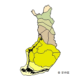
Suokasvillisuuden aluejako perustuu suoyhdistymätyyppeihin. Jako on digitoitu teoksesta Suomen kartasto, vihko 141-143, Ruuhijärvi, R.1988: Suokasvillisuus. Merialueen vyöhykerajat on digitoitu R. Ruuhijärven erikseen määritteleminä v.2002.
Aineisto kuuluu SYKEn avoimiin aineistoihin (CC BY 4.0). Aineistosta on julkaistu INSPIRE-tietotuote.
Käyttötarkoitus:
Aineistoa käytetään taustakarttojen tuottamiseen ja karkeisiin analyyseihin.
The mire vegetation zones dataset includes information on vegetation zones based on combinations of different mire types. The distribution of zones has been digitized from the mire vegetation maps of the Finnish map book (Suomen kartasto, book 141-143, Ruuhijärvi, R 1998: Suokasvillisuus). The mire zones are extended to outer sea areas based on the identification made by R. Ruuhijärvi on 2002. The Finnish national borders are based on the Digital Chart of the World (DCW) dataset with coastline corrections done by Syke. The dataset has been fitted to match the outer borders of the national waters (digitized in Syke).
This Syke’s dataset can be used according to open data license (CC BY 4.0).
INSPIRE compatible dataset has been published.
Simple
- Date (Revision)
- 2015-05-12
- Unique resource identifier
- http://paikkatiedot.fi/so/1002012/br/Bio-geographicalRegion
-
SYKE resource classification
-
-
Paikkatietoaineisto
-
- Keywords
-
-
INSPIRE-tietotuote
-
- Keywords
-
-
Suo
-
Kasvillisuus
-
Biomaantieteelliset alueet
-
-
High-value dataset categories
-
-
Maan havainnointi ja ympäristö
-
-
EU legislation
-
-
Arvokkaat tietoaineistot
-
INSPIRE
-
- Use constraints
- Other restrictions
- Other constraints
-
Creative Commons Nimeä 4.0 Kansainvälinen http://www.syke.fi/fi-FI/Avoin_tieto/Kayttolupa_ja_vastuut
Lähde: Syke
- Access constraints
- Other restrictions
- Other constraints
- no limitations
- Spatial representation type
- Vector
- Denominator
- 1000000
- Metadata language
- Finnish
- Topic category
-
- Biota
))
- Distribution format
-
-
ESRI shapefile
(
3.x
)
-
GML
(
3.2.1
)
- Specification
-
D2.8.III.17 Data Specification on Bio-geographical Regions – Technical Guidelines
-
OGC WMS
(
1.3.0
)
-
OGC WFS
(
2.0.0.
)
-
ESRI shapefile
(
3.x
)
- OnLine resource
- Syken Avoin tieto -palvelu
- OnLine resource
- Syken INSPIRE ATOM-syöte
- OnLine resource
- EliomaantieteellisetAlueet INSPIRE WMS -katselupalvelu
- OnLine resource
- EliomaantieteellisetAlueet WFS-latauspalvelu
- Hierarchy level
- Dataset
Conformance result
- Date (Publication)
- 2010-12-08
- Explanation
-
Tietotuotemäärittelyt Inspire-direktiivin mukaisten paikkatietotuotteiden osalta.
- Pass
- Yes
- Statement
-
Aineisto on digitoitu kuvaruudulta lähteenä Suomen kartasto, vihko 141-143, Ruuhijärvi, R.1988: Suokasvillisuus. Merialueen vyöhykerajat on digitoitu R. Ruuhijärven erikseen määritteleminä v.2002. Käyttö aineiston tarkkuuden puitteissa. Suomen rajat pohjautuvat Maanmittauslaitoksen avoimien aineistojen kuntajakoon 1:100 000, 2013, johon on Sykessä lisätty merenrantaviiva ja suurimmat Itämeren saaret Syken omasta rantaviiva-aineistosta.
The dataset has been digitized from a screen in Syke. The Finnish map book Suomen kartasto, book 141-143, part Mire vegetation, written by R. Ruuhijärvi 1988 was used as a base map for the digitizing. The mire zones are extended to sea areas based on the identification made by R. Ruuhijärvi on 2002. Information can be used in limits of the data accuracy.
- File identifier
- {193219CE-197F-4717-8D40-E7EDF6884A1E} XML
- Metadata language
- Finnish
- Character set
- UTF8
- Hierarchy level
- Dataset
- Date stamp
- 2024-05-20
- Metadata standard name
-
ISO 19115
- Metadata standard version
-
2003/Cor.1:2006
Overviews
Spatial extent
Provided by
